An app designed to help drivers avoid traffic proved helpful during a recent deadly flood. Traffic data from Waze helped government officials and first responders in Louisiana during Baton Rouge’s flooding in August. Esri announced a partnership with Waze and local governments on Oct. 12 to encourage more states and cities to use roadway data for similar projects.
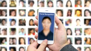
One in two American adults is in a law enforcement facial recognition database, which has the potential to disproportionately affect people of color, according to a report released by the Center for Privacy and Technology at the Georgetown University law school. A coalition of 52 civil liberties groups wrote a letter to the Justice Department, expressing their concern that facial recognition systems disproportionately affect communities of color.

PredPol uses data analytics on crime types, crime location, and crime date and time to tell police when and where to patrol, which is twice as accurate as maps that only plot past crimes, according to the company.

The White House Cancer Moonshot has placed a large importance on data, and there are many ways in which that data can be improved, according to cancer experts.

The White House announced the first five organizations receiving technology and training from Cloudera for continued support in working on the Precision Medicine Initiative.
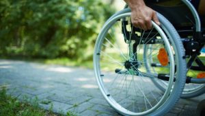
Jon Froehlich at the University of Maryland is working with a team of graduate students on Project Sidewalk, an online tool through which users can view their Washington, D.C., neighborhoods with Google Street View and label areas that may be inaccessible to those with impaired mobility.

The Baton Rouge Department of Information Services on Aug. 19 created an interactive map to track damage as the Louisiana city dealt with disastrous flooding. Within hours, 10,000 people, including rescue teams, had used the map.

The Massachusetts Turnpike is one of the latest roads to begin to feature all-automated toll collection systems, which cause privacy concerns due to the resulting databases of license plate photographs.

As the Precision Medicine Initiative continues its work to revolutionize how to improve health and treat disease, Cloudera has announced it will be donating its technologies to researchers and has pledged to train 1,000 of them in the latest big data technologies and data science techniques.